Resistivity, or electrical resistance survey, is a form of geophysical survey where electrical current is passed through the ground at regular points on a survey grid.
The electrical current is conducted through the soil by mineral salts dissolved in the ground water, and therefore the level of electrical resistance is to a large extent determined by the moisture content of the soil. Buried archaeological features with varying moisture content such as ditches and pits (often with higher moisture) and stone walls (often lower moisture) stand out compared to the soil around them, and can therefore be detected in the survey.
The patterns of resistance in the soil are recorded, plotted and interpreted, and can provide an accurate picture of buried ditches and walls that are invisible from above ground.
Resistivity
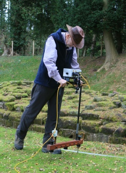
Paul Boothroyd conducting a resistivity survey at the Roman town of Isurium Brigantum